
How does Canada with a landmass of 9.985 million square kilometres and a coastline stretching for 243,042 kilometres (and covering three oceans), survey its sovereign territory? Adding to the challenge, the bulk of the nation’s population of 37 million people are located within 200 km of its southern border, leaving vast northern expanses of its sovereign territory, sparsely populated and thus arduous to monitor.
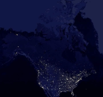
Image 1 shows a night-time view of the continental United States (U.S.) and Canada taken from space. It illustrates very graphically where the concentrations of populations are located. The outline of the continental U.S. is easily identifiable, whereas the vast majority of Canada is barely visible, accentuating its sparsely populated northern regions. Yet, as a sovereign nation, the Canadian government must possess full control over the affairs within all of its geographical area.
Such is the challenge facing the Canadian government, which has responded by stating that it will continue to “acquire space capabilities meant to improve situational awareness”[1] over its territory and it will further “invest in and employ a range of space capabilities, including space situational awareness, space-based earth observation, and maritime domain awareness,”[2] to meet its national and global Earth Observation (EO) requirements. To that end, the Canadian Armed Forces (CAF) were tasked to “acquire…space-based surveillance assets to significantly expand its Joint Intelligence, Surveillance, and Reconnaissance (ISR) capacity.”[3]
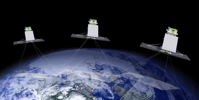
On 12 June 2019, the RADARSAT Constellation Mission (RCM) was launched providing Canada with a three spacecraft constellation of EO satellites that supply the Canadian Government with a range of ISR data supporting climate change research, agriculture monitoring, maritime surveillance, and Arctic sovereignty monitoring, to name just a few. Designed primarily for Canadian domestic EO requirements, the RCM has a good revisit rate of the Arctic region and of the maritime approaches to North America.
A satellite’s size, weight, fuel capacity, and battery life all play a part in its expected operational lifespan, more commonly referred to as a satellite’s design life. Generally speaking, EO satellites like RCM are currently designed with a 7-year design life. With this in mind, RCM is expected to operate to 2026.
The Defence Enhanced Surveillance From Space Project (DESSP) is the Department of National Defence (DND)/CAF replacement plan which builds on the current DND capabilities provided by RCM. The planned constellation is intended to significantly expand Canada’s ISR capabilities and will provide DND with a dedicated EO constellation that will meet its expanding operational needs. Planned improvements include the ability to differentiate between ships and icebergs in the Arctic, increased satellite revisit rates over key areas which provides for improved tracking and enhanced coherent change detection capabilities, as well as increased ISR support to CAF expeditionary operations around the world.
As a starting point, DESSP will continue to employ space-based Synthetic Aperture Radar (SAR) and Automatic Identification System (AIR) data, which have proven very effective for surveillance of the maritime domain. SAR can detect objects day and night and is not affected by cloud cover. Other requirements include Electro Optical Infrared (EO/IR) and Hyperspectral Imaging (HIS) capabilities. Electro Optical systems can provide high-resolution photographs of the earth. Commercially available data is available at resolutions of up to 30 cm. However, they cannot image at night or in clouds. Infrared imagery has traditionally been used in weather forecasting however, detecting heat sources at night has intrinsic military value. Images collected with hyperspectral sensors provide wide-area survey capabilities that can detect ground disturbances, the differential between camouflaged or hidden objects that contrast with the background, and identify chemical compositions of materials.
DESSP, as a dedicated DND EO constellation, is a departure from the whole of government use approach that RCM is currently servicing. Part of the reason for this is the increased demand for space-based ISR data to support CAF operations which would leave little room for other government departments’ data requirements. Departments such as Natural Resources Canada, Environment and Climate Change Canada, Transport Canada, Fisheries and Oceans Canada, all compete for limited RCM EO coverage, each requiring specific, and often different, radar frequencies and beam-modes for optimal data collection. Thus, compromise normally results in less than ideal imagery for certain tasks as system operators try to accommodate multiple data demands for the same areas.
Additionally, the security of data collected for DND purposes differs from those of other departments. The CAF’s support to military operations, and standing agreements with its allies, demand that the data collected be controlled in the interest of national and allied security. By contrast, other government departments prefer an open-source data policy that makes the data more available to others. Both requirements have merit and when combined with the capacity restrictions associated with a single whole of government system, it led DND to seek a separate, purpose-built constellation.
Government funding for two EO constellations will be a considerable hurdle. DESSP is estimated to cost between 1 and 4.9 Billion dollars. That significant variance in price is based on various capability options currently under review. The preferred option will be selected by DND when it reviews the capability options later this year. Current DESSP milestones outline contract award in 2027, for a launch in 2033. At the same time, the Canadian Space Agency (CSA) is moving forward with the Earth Observation for Service Continuity (EOSC) project, which represents the needs of other Canadian government departments that will require space-based EO data after RCM. Information such as soil moisture content, arctic sea ice movement and reduction levels, and forestry studies, are but a few examples of the kind of ongoing domestic observations that EOSC would support, and the CSA has spent $4 million for studies that will explore possible future Canadian EO systems. As mentioned earlier, the challenge for CSA is how to satisfy diversified requirements that demand different modes of operation, varying radar frequencies, and competing revisit times. The answer is compromise and it has resulted in CSA’s ongoing effort to harmonize multi-departmental EO requirements. Interestingly, CSA has included DND requirements in its long harmonized list, even though it is well aware of DND’s intent to go it alone with DESSP. With EOSC estimated to also cost in the billions of dollars, it is unlikely that the cash-strapped Canadian government will fund both constellations if they are contemporaneous.
However, the CSA is looking at options that would “ensure that Canada is able to seamlessly maintain this [EO] capability and enhance the operational services beyond 2026”[1] which is the expected end of service date of RCM. Given the horrendous timelines for government procurement in Canada, CSA’s aim to ensure space-based ISR services continue seamlessly after RCM could be the answer DND needs to fill the current 7 years gap in space-based ISR capability that exists between 2026 and DESSP’s planned launch in 2033.
DESSP’s significant capabilities to provide active wide-area surveillance, global maritime domain awareness, enhanced earth observation, and coherent change detection will enable the CAF to “remain ready to act in the service of Canadians – from coast to coast to coast – and sustain a continuous watch over Canada’s landmass …and sea approaches,”[2] thus, it is strategically relevant. It will significantly enhance the CAF’s space-based ISR capabilities beyond RCM, employing a smart mix of space-based sensors that will provide more advanced ISR support to the CAF, NORAD, and NATO operations. There is little question that the Canadian government has clearly stated the requirement for DESSP, but with no government strategic plan for space and a growing federal deficit, will it be funded?
[1] spaceQ.ca, https://spaceq.ca/the-canadian-space-agency-awards-8-contracts-for-studies-of-future-earth-observation-systems/ Background, para 2
[2] Canada’s Defence Policy (2017), “Strong, Secure, Engaged”, Chapter 5, Strong at Home, Pg-60
[1] Canada’s Defence Policy (2017), “Strong, Secure, Engaged”, Chapter 2, Investment in the RCAF, Point 45, Pg-39
[2] Canada’s Defence Policy (2017), “Strong, Secure, Engaged”, Chapter 6, New Initiatives ,Point 85, Pg-72.
[3] Canada’s Defence Policy (2017), “Strong, Secure, Engaged”, Executive Summary, Pg-15