Since its inception in 2012, the Canadian Space Operations Centre (CANSpOC) has provided valuable support to Canadian Armed Forces (CAF) operations, delivering space-domain awareness, battlespace information and space capability on a daily basis.
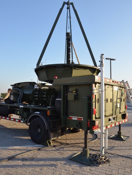
One of those capabilities, currently operated by the Joint Signals Regiment, is the Unclassified Remote-sensing Situational Awareness (URSA) satellite imagery receiver system, a mobile self-contained workspace for the collection, production and utilization of imagery. The technology enables selected satellites to directly downlink unclassified high-resolution imagery of theatre operations.
In general, once a satellite has taken an image, no matter the location around the globe, downloading of that image can only occur when the satellite flies within “line-of-sight” of fixed downlink sites, usually in specific Canadian locations. It could be hours before a satellite is within range to downlink, and only then can an image be processed and relayed back to a commander in the field.
With URSA, images can be processed and simultaneously downlinked directly in a deployed location. An image analyst can take an image to the commander a mere 30 minutes later.
On July 27, 2016, responsibility for the Director General Space organization was transferred from the Vice Chief of the Defence (VCDS) to the commander of the RCAF during a brief ceremony at the Canadian Aviation and Space Museum in Ottawa. Responsibility for URSA soon also will be transferred to the RCAF.
How URSA works
Commanders’ imagery requests are relayed to the URSA team who format and send the requests to appropriate satellite-tasking agencies.
Eligible commercial satellites that are within line-of-sight to the URSA antenna are then tasked to collect imagery and downlink the data to the URSA on its next overflight.
Once the imagery is downlinked, the URSA system and team process and format the data into useable imagery which is presented or transmitted to the commanders and staffs who requested the imagery.
A recent software upgrade to URSA now permits the use of Canada’s RADARSAT-2 satellite to provide Near Real-Time Ship Detection (NRTSD) capabilities, greatly enhancing commanders’ situation awareness and the accuracy of the Recognized Maritime Picture (RMP).
Shareable imagery
A principal factor that makes URSA so advantageous to commanders is that it receives data from both optical and radar-based satellites to provide direct delivery of unclassified – and therefore shareable – commercial satellite imagery, giving deployed commanders pertinent imagery of their area of interest (AOI).
It provides global access to an AOI outside the reach of other tactical sensors. As this imagery can be shared with partner nations, it improves the CAF’s effectiveness and interoperability in multinational operations. URSA can be deployed anytime and virtually anywhere the CAF operates, making its technology extremely useful for Navy, Army and Air Force commanders in charge of deployed or domestic operations, as well as for non-NATO and non-Five Eyes nations,[1] or even local law enforcement agencies that may be contributing to a CAF operation (as determined on a case-by-case basis).
“URSA will improve the CAF’s operational capability by eliminating the need for reach-back imagery support,” said Brigadier-General Blaise Frawley, the RCAF’s Director General of Space. “This will mean reducing delays and increasing situational awareness in near real-time, a real boost for continued mission success.”
While the CAF has used URSA domestically since 2014, the system will be employed on deployed operations for the very first time at the end of December 2016, where it will directly support Operation ARTEMIS, the CAF’s contribution to counterterrorism and maritime security across the Red Sea, the Gulf of Aden, the Gulf of Oman and the Indian Ocean.