The screen on the wall shows a jumble – strange lines, odd words and letters in bizarre colours and fonts, a mish-mash of who knows what.
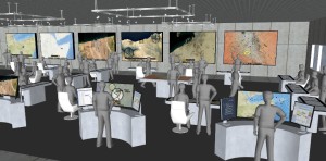
We’re gathered at the Thales offices in suburban Ottawa in a room whose large windows give it the name the fishbowl. Alain Gauthier, vice-president, Secure Comms and Information Systems, has brought me in here for a visual tour of the Battlefield Command System Thales has created for the Canadian Army.
The cheerful multi-coloured insanity I am seeing is a contrast to the more somber displays of maps and military units visible on laptops scattered about the room on long tables. In fact, it is an attempt by some army end-user to break the system. This isn’t vandalism. It’s the final step that Thales takes before it rolls out yet another iteration of the Battlefield Command System. Says Gauthier: “You don’t want to find out that something doesn’t work at 2 o’clock in the morning in Afghanistan.”
Look inside any army command post in the field, visit an exercise at the staff college, and you’ll see Thales’s Battlefield Command System (BCS) displayed on PCs or ruggedized laptops. This is the system that brought the army into the digital battle of the 21st century. And Thales can claim much of the credit.
At its heart, you could call the BCS a fancy way of displaying maps. And when you look at a computer running it, that is what you typically see – a topographical map. That’s not surprising. As Gauthier, a former army officer, says of the military, “It’s what we know.” But it is much more. Working directly on the screen, a commanding officer and his staff can plot units and vehicles – both friendly and otherwise – and move them, outline areas of particular significance (say, a zone to be hit by artillery fire), stay up-to-date on developments in the battle space thanks to a running tickertape, and chat with one another in real time using a social media function.
These various add-ons are accessed through on-screen, touch-sensitive toggles. The system can bring in feeds from elsewhere – overlaying the video from a UAV onto the map interface, for example, a technique Gauthier calls “layering.”
In the interest of security and efficiency, BCS also allows information to be controlled by “profiles” – while the commander would see everything, “if you’re an intelligence guy, you see what you need to see, if you’re logistics, you see that.”
Equally important in a coalition battle space, the BCS is interoperable with similar systems used by allies, thanks to JC3IEDM, a “data model” used by all NATO nations. “All the nations,” says Gauthier, “sign up to define how information is shared.” If the Canadian system shows three tanks or an enemy platoon and it shares this information with allies using different systems, they see the same thing.
The origins of Thales’s BCS lie back in the 1990s when the army was looking to make its transition from “maps on the wall,” as Gauthier puts it, to the digital realm. Rather than creating something from scratch, the army went looking for an existing system that could be modified to suit Canada’s needs. The French SCIF system, created by Thales, seemed a good starting point. Thales was initially brought in as a sub-contractor by General Dynamics in the late 1990s, and then began working directly with the army in 2002.
In 2008, Thales was awarded a five-year contract to be Canada’s prime contractor for command and control software.
“This was at the height of the Afghan deployment,” says Gauthier. “They [the army] were evolving their requirements based on the operations they were conducting, and we had to be very flexible and responsive to bring in the mission-critical functionality needed by the Joint Task Force.” Thales technicians deployed to Afghanistan to assist in the management of the Land Command Support System.
“Something that we had to come up with really fast was the ability to bring in the feeds from UAVs (unmanned air vehicles). All of a sudden, we had to bring in live video. It’s not only a challenge to bring it in, you have to find the bandwidth and then show it in a fashion that is legible to the commander.” It’s a sign of how satisfied the army is with Thales’s work that their contract has been extended for three more years, to 2016, with an option for a further two after that.
What’s the future? “The system started off at the formation level, the brigade HQ,” says Gauthier, “then we brought it down to the battle group – in the turrets of the vehicles. The next iteration will be the dismounted soldier. You want to have ‘shooter’ to ‘decider’ integration.”
Ian Coutts is a freelance writer, author of four books, and a frequent contributor to Vanguard.