Major Ali Laaouan sits back and considers the question for a moment. What are the critical elements to a fixed wing search and rescue (FWSAR) aircraft? Although it is early afternoon, the sky has darkened considerably outside Maritime Forces Atlantic (MARLANT) headquarters in Halifax, and the rain, driven by a strong wind, continues to pelt against the window.
Though hurricane season is well underway in the Atlantic, this is just a mild, wet day. Nonetheless, the weather is a reminder of the conditions in which Canadian Forces search and rescue personnel have earned an international reputation.
Laaouan is the Officer in Charge of the Joint Rescue Coordination Centre Halifax, a SAR operation with one of the largest and most complex areas of responsibility (AOR) in the world, 4.7 million square kilometres of land, sea and ice that stretches from the 70th to 30th meridian west – the eastern portion of the province of Quebec to the middle of the Atlantic Ocean – and includes 29,000 kilometres of coast line, much of it in the low Arctic up to 70 North on Baffin Island.
“Endurance,” he says after some thought. “Given how big the area is, I need to be able to get there and then do something. I wouldn’t go to 30 west on two engines on a day where there’s icing. We just had two engines flame out on a Hercules during a search.”
His boss, Rear-Admiral David Gardam, commander of Search and Rescue Region Halifax, MARLANT and Joint Task Force Atlantic, nods in agreement. But Gardam also has a key technical requirement. “To me, it is all about getting the asset on time with the capability to do something. Just because we get an asset on time, if we can’t deploy the SAR technicians with their equipment, they’re useless. So the biggest issue with FWSAR has and always will be a ramp.”
Small surprise then that both endurance and a rear ramp are among the mandatory requirements for the government’s FWSAR program, according to a draft of requirements provided to contending companies during a workshop hosted by Public Works and Government Services in October.
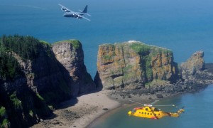
The FWSAR program is intended to replace the CF’s rapidly aging deHavilland CC-115 Buffaloes, all operated by 442 Transport & Rescue Squadron at CFB Comox. For Laaouan and his team, the dedicated SAR aircraft are the Lockheed Martin C-130 Hercules and the AgustaWestland CH-149 Cormorant helicopters.
A new aircraft might not necessarily change their response “package” of Hercs, Cormorants and a few Bell CH-146 Griffon helicopters, but they are watching the process closely nonetheless because the scope of their AOR is indicative of the challenges all three of the Canada’s Joint Rescue Coordination Centres face.
“If you do a SAR in the winter, you are dealing with ice, fog, harsh seas, bitter, bitter temperatures and with people who have minutes of survival time if they are in the water,” Gardam says. “You are also dealing with very long distances and very complex coordination problems.”
“To put it in perspective, I tell people we are responsible for search and rescue halfway to Europe,” Laaouan adds.”Then it hits them: how do you rescue someone from just inside 30 west?”
The solution? Aircraft with endurance and enduring partnerships, both domestic and international.
The Canadian Forces are only responsible for aeronautical and maritime search and rescue, a fact not always understood since National Defence assumed responsibility for federal SAR 65 years ago; ground SAR is the responsibility of each province, which often rely on police agencies like the RCMP.
Both, however, rely on each other and a myriad of private sector partners through well-established procedures and protocols. “We have to have the ability to reach out to every possible asset, to all vessels of interest, to all the resources that are out there,” Laaouan says.
As important as aircraft are to the JRCC, Gardam is quick to point out that maritime SAR often involves drawing on nearby government vessels and commercial and civilian ships to assist with everything from trauma injuries to engine failures to fires.
That complex coordination extends well beyond the AOR of JRCC Halifax. Under international convention, every centre is accountable for all distress beacons it receives, regardless of where they originate. “If we are the first people to receive a distress beacon from the middle of the Gulf of Oman, we are responsible for that distress until we are able to confirm that someone else is dealing with it,” Gardam explains. “Even in our own region, we cannot always do it by ourselves. So we rely on a lot of other agencies to help us and we do the same thing for them.”
To illustrate the point, Laaouan describes a recent distress call in Nunavut involving a father and son in a small open boat. The initial details confirmed only a small boat in distress. “We knew we could have sent a Herc, but it was a long distance and we knew there was a Cormorant (not one of ours) transiting the area to Iqaluit. And we knew that Transport Canada was doing some testing on NavCanada assets up there. So we used those two aircraft to locate and then pick them up. The boat had reached shore so, jurisdictionally, who is responsible? We will never ever fight to determine jurisdiction if someone is in distress. A spot beacon is a distress, so we’ll respond and figure it out after. However, when the provinces know it is in their jurisdiction and they ask us for help, that’s where the risk assessment comes into play.”
The tragic death in January of 14-year-old Burton Winters near his home in Makkovik, Labrador, reinforced the importance of well-understood protocols. The Canadian Forces faced a maelstrom of media criticism over its response, but Gardam says protocols were followed. He has since made a key change, however. “In the past when a call would come in for a potential ground SAR, if they didn’t call back to say they needed something, even if we said call us back, then we’d say obviously there is no requirement and we’d close the file. Now we have a call back mechanism in place: we will proactively go back and ask, are you sure you don’t need us? And we’ll still continue to monitor until they close the file. That’s the change we made. Through tragedy you can see where maybe, collectively, the ground SAR organization could do some things better. When it’s critical and people are going to die, we will always respond. And the provinces know that. Not every case is critical, so this is where the relationships come in, where trust and understanding are key. We’re getting better at it. It’s a constant process.”
Adds Laaouan: “We deal with five provinces and one territory within our SAR region and we work with them on a daily basis, on a weekly basis to ensure that we are all on the same page and that the protocols are understood. We care about the people and we don’t want any politics to hinder our efforts. So the more we communicate, the more we work together, the better our protocols are going to be. And as long as the folks doing the job understand the protocols in place, we can work like a well oiled machine. That case reinforced the importance of doing that. Everything was in place already but it reinforced that we need to do this on a regular basis.”
Being on the same page took on even greater significance in May 2011 when Canada signed on to an Arctic Council agreement to cooperate on aeronautical and maritime SAR in the Arctic, a binding agreement that divides the entire Arctic Ocean and land masses into zones of responsibility. Though the agreement does not change Canada’s three AORs at present – under the UN Convention on the Law of the Sea member countries are still working out their Arctic territorial claims – it does call for SAR assets to be positioned to provide rapid assistance and encourages each member country to maintain “an adequate and effective search and rescue capability.”
At present, Canada does not have a dedicated Arctic JRCC. All three centres share a piece of Canada’s North, with Trenton responsible for the High Arctic. In fact, all aircraft but four CC-138 Twin Otters based in Yellowknife are located in southern Canada. Gardam acknowledges that might have to change one day, though he believes the status quo will work well for the time being. “Right now I’m very happy with the basing of the SAR assets we have. I think we are among the best in the world in our response times and our ability to do our job, which is to save lives. That’s now, but in 10-15 years we may be saying as a country we need more capability up there.”
Would recent calls to consider alternative service delivery of search and rescue, including outsourcing aspects of SAR, affect those critical partnerships? Most outsourcing suggestions have advocated that the Canadian Forces maintain authority over performance and safety standards, which could include it’s well-oiled coordination role. Gardam is pragmatic about the idea, though proud and protective of what his people do. “We have a phenomenal system, I would argue the best in the world. If Canadians are willing to accept something less than that, outsource it. But that’s a decision for the government of Canada to make. Canadians look at certain things we do as an institution and say, they do it right. But it costs money. It’s all about cost and reward.”
SIDEBAR
SAR sensor suite
If every Royal Canadian Air Force platform is a sensor, then the integrated sensor suite will be a key component of the next FWSAR aircraft. In October, industry was informed that the “aircraft must incorporate an integrated sensor suite including radar and multi-spectral electro-optical/infra-red (EO/IR) permitting all-weather day/night detection, classification and identification for all targets of interest.”
Specifically, the mandatory requirements include:
• an EO/IR system with the ability to detect, classify and identify various SAR targets of interest, day and night, with enhanced capability during low thermal contrast conditions through cloud, fog, smoke, haze and precipitation, and the ability to read aircraft and vessel registration under the same conditions;
• a radar capable of over-water searching, detection and classification of surface targets in various sea states and target density conditions, and able to manually and automatically track surface targets, up to 50 simultaneously, and display that data in multiple colours with a contouring feature;
• Automatic Identification System (AIS) for identifying and locating surface vessels and displaying such information to the Sens O sensor station;
• a moving map for situational awareness; and
• a sensor station for the Sens O with the capability to record full motion video (FMV) and single frame images with meta data as deemed appropriate by the Sens O and allow real-time use and review, and receive and display the sensor information (including weather information) in a format suitable for directing the aircraft to the target of interest.